The Climate Smart Agriculture (CSA) simulator presents alternative scenarios for managing a farmland by describing current management practices and alternative future management scenarios.
The tool addresses mainly future farmers, students, expert farmers, farmers’ associations and organizations that are interested to acquire CSA-related skills or to upskill their farming competences and to test them into a virtual environment.
It is a suitable training/learning tool that offers simulation-based education and improves trainers’ and learners’ confidence with agritech and will also be used as a forecasting and management tool for learners and farmers to experience project-based learning.
It applies a workflow based on algorithms: different algorithms are developed for different agricultural lands and are then integrated in a model-based software architecture optimized for distributed processing; simulation workflow optimization is an important investigation area as it allows users to process large scale & heterogeneous problems in a more flexible way.
The Simulator is designed in order to be harmonized with the Massive Open Online Course (MOOC), in the view of a coordinated strategy for online agricultural education: the interaction between research, education and innovation activities within the simulator project will be responsible for coordinating the different approaches, incorporating several existing models.
Why is CSA simulator useful?
Specifically, taking into account the complexity that characterizes the relationship between cultivation systems and the amount of carbon dissolved in the soil, the availability of a simulation environment will be able to provide simplified and immediate use of “forecast” indications inherent to the progress of the Soil Organic Carbon (SOC) and Soil Inorganic Carbon (SIC) according to the agricultural practices adopted and attributable to the CSA approach.
CSA Simulator:
- allow learners, small farmers and growers, to simulate in a virtual environment the benefits on a given area of implementing the Climate-Smart Agriculture (CSA) measures presented in the Massive Open Online Course (MOOC);
- allows an improvement of the level of understanding and knowledge and facilitates the access to innovative and simulation-based agriculture education and solutions;
- is a software component that will be included in the MOOC web portal in order to support projective simulations based on deterministic models;
- is designed in a modular way, in such a way that learning goals will be achieved not only by motivated students, willing to have a well-rounded education, but also by those participants having (due to lower interest or work commitments) limited time or attention availability.
The tool uses detailed spatially-explicit data on the condition of a particular soil and allows to enter information for field operations, producing an estimate tailored to specific situation.
It has as output the extraction of information regarding Soil Organic Carbon (SOC) and Soil Inorganic Carbon (SIC).
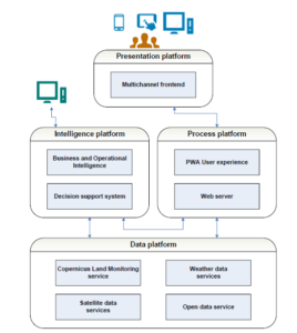
Architecture and Design Climate Smart Agriculture Simulator
What information is needed?
The tool only needs information on the agricultural area of interest and the management practices adopted.
For example, the tool:
- provides for the selection of the agricultural area of interest (AOI) among those available for the simulation session;
- retrieves the geomorphometric information of the AOI through sw components for the use and processing of European Digital Elevation Model EU-DEM v1.1 (EU-DEM v1.0 update); the dataset is a digital surface model (DSM) is a hybrid product based on SRTM and ASTER GDEM data fused by a weighted averaging approach (the statistical validation documents a relatively unbiased overall vertical accuracy of 2.9 meters RMSE);
- provides a set of biophysical variables which describe the state and the evolution of the vegetation, the energy budget, the water cycle. etc. over the surface of AOI; the development of this spatial indicators is based on the use of earth observation data produced by the “Sentinel” satellite constellation (Copernicus is the European Union’s Earth Observation Programme);
- requires the indication of crop management practices, including cropping sequence, type of grazing system, type of tillage system, rate, timing, type and application method for fertilizer and manure applications, irrigation method and application rate, and residue management (in order to simplify the simulation session, the choice of agronomic practices will be made through pre-configured options);
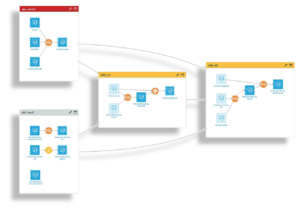
One of the workflows tested within the simulator
How does CSA simulator model scenarios?
The CSA simulator is based on an intelligent software platform that supports predictive modelling to build simulation environments by defining ‘scenarios’ that operate on specific data sets:
- a data set is the central object that is manipulated (AOI, geomorphometric information and biophysical variables);
- a scenario is a set of actions to be done, with conditions to execute it (land management practices).
- a dashboard, combining a set of graphical and textual objects, makes the information generated by the simulation accessible in real time.
The tool uses the information on land management practices together with spatially-explicit information on soil conditions of AOI to run a series of models for each potential scenario.
These models are aimed at increasing knowledge about the methods and tools available for agricultural land management and point to where research and development are heading that may be useful for the farmers.
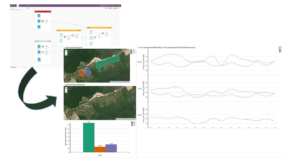
Climate Smart Agriculture Simulator
Stay tuned that in the coming weeks we will continue to update our project page and will definitely bring you more news and features on the simulator.

